
The world hasn’t forgotten the mess with Apple’s Maps app earlier this year. This time it was Google’s turn to feel a little embarrassed as its much lauded Maps application showed an island which doesn’t exist. The island is shown somewhere in the middle of the South Pacific and is considerable in size and dimensions. However, geography experts have clarified that no such island exists in the spot where it is being shown by Google Maps.

Sandy or Sable Gone Invisible
The Google Maps feature called the isle Sandy while other charts listed it as Sable Island. This means that Google wasn’t the only publisher or company responsible for creating the confusion. The negligence came to light when a ship carrying Australian scientists passed through the very region where the island is shown on the maps. The navigation system or the maps used by the ship’s crew show no isle in their path.
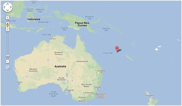 According to Google Maps, the island was around 60 square miles long. However, when the scientists went towards it, they found there isn’t any island at all. They followed the exact coordinates as laid out by Google and other map publications. They didn’t find anything there except clear blue waters. Supposed to have been somewhere between New Caledonia and Australia, the ship found no signs of an island.
Researcher Saves Google’s Blushes
What could have been a very awkward position for Google and other map publishers was saved by a New Zealand-based researcher. The other map publications are little-known as compared to Google. If Google Maps had been showing the island which doesn’t exist, the company would have picked up a lot of flack. Google had been one of the companies involved in mocking Apple when the Maps mess occurred though it was Google who ultimately agreed to solve the problem.
The researcher based in New Zealand has clarified the situation. He claims that no such island existed in the first place and the only reason it got published on different maps since 1876 was because of an error made by a whaling ship. The researcher, Shaun Higgins, said that what they would have considered an island was probably a reef or a series of reefs which are commonplace in the Coral Sea stretch between Australia and New Caledonia.
Given the fact that the technology available to sea travelers nowadays is far more advanced than anything back in 1876, it is quite possible that the crew made a mistake. A mistake made over a century ago could have led to a major embarrassment for Google. It is unlikely the crew of that whaling ship could have such foresight back then.
Sandy Goes Off the Map
For now, it seems that the mystery has been solved and the map publishers can rectify the mistake. According to reports, Google has removed Sandy Island from its maps along with a statement repeating Google’s efforts to constantly update the information it provides to people. It certainly has been an interesting event for the tech giant for whom the regular news is regarding new products, acquisitions, lawsuits and money.
[Images via thedroidguy & digitaltrends]